The most popular route is from Wasdale Head up a path which many people refer to as the "Tourist Path" or "Main Path" or the "Brown Tongue route" or the "Hollow Stones route". Wainwright's guide describes this route in Scafell Pike 13. If you are new to hill hiking or have no-one experienced in your group then route 1a IS the route for you. You will still need good weather, adequate clothing, good footwear, food, water and a map or reliable specialist app (not google maps). See my general tips for walking the Wainwrights. Start: Just south of Wasdale Head car park, between the car park and the bridge OR near the southern camp site on the road to Wasdale Head Hall Farm. These two paths soon join together. At the time of writing parking at Wasdale Green was free but cost £9 (cash only, 2024 price) at the NT car park near the camp site.
Main Route 1a: The paths from both starting points join together and ascend Lingmell Gill. After fording the stream it heads up over Brown Tongue and Hollow stones along a zig zag section and then up to Lingmell Col. It then turns right and up the final ascent. Choices: As you can see above there are two places you can park for the start. There are also choices further up. 1a: Stick to the main trail all the way - total will be 3 miles, (3 hours) up and a little less down. The path varies from gravel path lower down to rocky paths higher up and has a constructed rock path and steps for some stretches. 1b: This separates from 1a quite early on and takes the path left over Lingmell which is a Wainwright. It gets steep earlier on and is slightly longer but much less busy so much quieter. It can take in the summit of Lingmell although there are several paths in the top part which eventually join together so you could do this from 1a anyway. The path is much more track over grass with some rocky bits. At Lingmell Col it rejoins 1a. 1c: This separates from 1a further up taking a path to the right towards Mickledore. It is also much less busy than 1a from this point. Its slightly shorter than 1a, in fact this is the shortest of any of the routes, but it is not likely to be much quicker. There are dramatic close up views as you approach Mickledore with the rocky sides of both Scafell and Scafell Pike towering above you. The path is much more rocky track and goes through a scree section below Scafell. The 1c route includes a rocky scramble near the top as you reach Mickledore. Scramble means you will need to use hands as well as feet. The scramble is generally considered fairly easy as scrambles go although obviously not if you don't like scrambles. It is very rough and care must be taken. Its generally easier to go UP ground like this than DOWN because you can see where to place your feet better and holding on with your hands is easier. Its in a gully with rock all around you so does not feel exposed. (Exposed is the word that hill walkers use for ground that gives you the nasty feeling that you are going to fall off it.) You can take any of the routes back to Wasdale Head for the return ie any of these or 4a or 4b or 2b to styhead and then 4b. Advantages of this route: Shortest routes, under 3 miles each way. Simplest navigation on main route 1a. Good path. Lots of other people around at popular times on 1a. Easy parking although it can fill up at busy times. Choice of 3 main routes. No scrambling on 1a or 1b. Can easily add on Lingmell if taking 1a or 1b. Circular route possible eg go up 1a and down 1b. Pub and small shop at Wasdale Head. Disdvantages of this route: 1a is the busiest/noisiest route and often has a lot of people on it. Although many of the other routes have some steep parts these route 1 paths cover the height in the shortest distance, so overall they are the steepest. (see route profiles below) There is one water crossing - a small rocky stream called Lingmell Gill on routes 1a and 1c - this is not usually a problem however after a very wet spell, especially in winter, it can become problematic and maybe even impossible to cross safely. You may have to hunt for a way across further up in this case or use 1b which has no water crossing. The shop in Wasdale Head is not big enough to rely on for provisions for the day. The main disadvantage however is that the start point, Wasdale Head, is very remote. Its a 90min drive from Ambleside while Seathwaite (route 2 below) is 45min and Langdale (route 3 below) is only 15min. From Keswick its a 75min drive while Seathwaite is only 20min. The road along the side of Wastwater is very picturesque but hard work for the driver at times especially if busy. Its quite rough and narrow in places and its the only road in. All this also applies to route 4 of course.
|
|||||
 |
|||||
 |
|||||
Another popular route is from Seathwaite to Styhead Tarn and then along the Corridor Route. This route is described in the Wainwright guides at Scafell Pike 15 and 16 (and Scafell Pike 18 for my route 2b) Start: Road at Seathwaite Farm. There is free parking on the road leading up to the farm but if this is full the farm sometimes opens a field for paid parking, about £5 all day (2024 price). Main Route 2a: The route starts along the valley floor from Seathwaite Farm before turning right at Stockley Bridge. It ascends over Greenhow Knott and along the side of Styhead Gill which it crosses at a small bridge. It continues past Styhead Tarn to the Styhead Stretcher Box, then turns left across Styhead and then right and the corridor route starts. (It is easy to miss the final right turn, which would mean you would be walking route 2b towards Esk Hause.) The corridor route ascends across the side of the fell with some steep parts and places where it has to cross streams coming down the fellside. There is one short downwards scramble over a large rock section which lasts about 1 minute. After passing the top of Piers Gill it rises to meet route 1a at Lingmell Col where it turns left for the final ascent. Choices: 2a: Take main path as described above - total will be 5 miles 5 hours each way. (NB take a look at 4c below as an alternative for the last bit.) 2b: From Styhead take the path up the side of Great End towards Esk Hause then around the back of Great End and along the rocky ridge over Blunt Top and around Broad Crag. (slightly longer than 2a but arguably better views as you are up higher for longer, so perhaps not as good if the cloud is low - you'll be in it for longer. Great End summit is a very slight diversion for a good viewpoint and a Wainwright). 2c: Yet another route from Seathwaite is to walk along to Stockley Bridge as before but carry on along Grains Gill and then up Ruddy Gill, walking between Seathwaite Fell and Glaramara. This brings you out just below Esk Hause joining route 2b, so misses out Styhead and the corridor route completely. Turn left to continue up to Esk Hause and then right to walk around the back of Great End and along the ridge to Scafell Pike as for 2b. I'd say the stretch up Grains Gill and Ruddy Gill is rather harder walking than going up 2a to Styhead. Advantages of this route (2a): Popular route with variety of views and types of walking. Most gradual route ie fewest prolonged steep uphill stretches. Some help around. Parking at Seathwaite - as well as parking on the road the farmer usually offers parking in a field for a small fee. Convenient start/end - Seathwaite is much closer to Keswick. Less busy route than 1a. Nice half way break at Styhead (not 2c). Some part circular options ie. You can eg take 2a up and then 2b back and rejoin your original route from Styhead or switch to 2c. Disdvantages of this route (2a): Longer than route 1. Better navigation skills needed and preferably someone who has done it before. Make sure you find the correct path from Styhead (see arrow on pictures below). There is one short scramble on the corridor route(2a) - click here for details of the scramble. Seathwaite is used as a starting point for other walks too so parking can sometimes be busy. Pub slightly further from start/end.
|
|||||
|
|||||
A more unusual route is from Langdale. This route is described in the Wainwright guides at Scafell Pike 19 where he says it is "for strong walkers and supermen only" ! Start: Langdale eg Old Dungeon Ghyll pub and then the end of the B5343 where there is a 90 degree corner. (There is an alternative for the first part of the route that starts behind the pub and takes the path on the north side of the valley into Mickleden - dotted on my map) Main route 3a: The path leaves the road and heads across some fields along the valley floor to Stool End farm then turns right, crosses the river and continues along Mickleden. At the bottom of Stake Pass it turns left and after ascending Rossett Gill it passes Angle Tarn and then ascends again. As you approach Esk Hause it turns left and after another short ascent bears right up the side of Great End. At the top it turns left and follows the ridge, passing between Ill Crag and Broad Crag before the final rocky ascent. Choices: from just below Esk Hause which is about 3/4 of the way: 3a: Main route as described above. Would be 6 miles 6.5 hours total one way. The upper part of this route is the same as 2b. 3b: Down to Styhead then Corridor Route. (ie same as 2a) This route makes no sense to me as it is much longer and loses so much height dropping down to Styhead but some people do it if they do not want exactly the same route both ways. (Total 8 miles 8 hours one way) Advantages of this route: Interesting route with excellent and varied views. Parking options in Langdale. Gentle start. Quieter route. Convenient start/end especially from Ambleside. Nice stopping points at Angle Tarn, Esk Hause and passes close to other Wainwrights eg Rossett Pike, Allen Crags, Great End so lots of route options to consider higher up if Scafell Pike becomes undesirable eg Esk Pike and Bowfell from Esk Hause. 2 pubs in Langdale. Disdvantages of this route:The longest route, more than 6 miles each way. Better navigation skills needed and preferably someone who has done it before. Limited circular options mean that most people will reverse the route for the return (although it is possible to come back over Esk Pike and Bowfell if you are superhuman).
|
|||||
 |
|||||
 |
|||||
Although they also leave from Wasdale Head these are very different routes compared to route 1. They start by heading north up the valley from Wasdale Head following Lingmell Beck and ultimately around the other side of Lingmell. Route 4a is described in the Wainwright guides at Scafell Pike 14. Start: Wasdale Head Green car park. Main Route 4a: This route heads gently up the valley and passes under Great Gable along the side of Lingmell Beck which it eventually crosses. (This could be difficult if there is a lot of water in the beck.) As the path bends right it begins to ascend more and crosses a smaller stream then continues to climb before passing below Criscliffe Knotts. It then reaches a short rocky scramble before Middleboot Knotts and a little further up gets close to the edge of the gill before joining the top of the corridor route (2a). Here it turns right and then a few minutes later, left, at Lingmell Col where it joins route 1a/1b for the final ascent. Choices: 4a: main route as described. (total 4 miles 4.5 hrs). 4b: separates from 4a quite early, before any ascent, and takes the path up the flank of Great Gable to Styhead. This is a straightforward solid path. Then at Styhead take the Corridor Route (2a) or Great End route (2b). (Both a mile and an hour or so longer than 4a). 4b is really a very different route to 4a. 4c: If using 4a there is another possible end to the route. Turn right onto the corridor route then soon afterwards turn left onto a path that runs up between Broad Crag and Dropping Crag. This meets the routes that come across from Great End, just before their final ascent to the summit. This is only a short section, all of the route is visible up to the col if the weather is clear, however it is quite steep and rough with some scree climbing. This is going to be a much quieter section than the busy routes that lead up from Lingmell Fell and is also slightly shorter possibly saving a few minutes, but it is a bit more challenging. Wainwright calls this "a good alternative". It is also possible to do this from any of the routes that use the corridor route of course (4b,2a,3b!). Advantages of this route: Dramatic route. Good parking. Very quiet route especially 4a/4c. Long warm up before much climbing in lovely scenery between Lingmell and Great Gable. Only slightly longer than route 1. Many circular options ie return can be done on any of the routes back to Wasdale Head eg go up 4a and down 1a. Pub at Wasdale Head. Disdvantages of this route: Remote start/end (as for route 1). Some scrambling near Middleboot Knotts (not 4b). Limited help available from other walkers (especially 4a). Crosses Lingmell Beck may be difficult if flow is high (4a). Navigation more difficult because the paths are smaller and it might be problematic in poor visibility or winter. We did this route in good weather in August 2020 and added on Scafell and Slight Side as well. This (4a) is really the route with the most significant danger. Piers Gill is a dangerous ravine - this route is along a path above it where care is needed, but it does NOT go into the ravine, which is highly dangerous to attempt without climbing equipment and knowledge. Even on this route there is some possible danger - if you fall in the ravine you will probably die. Do not approach the edges to peer in. Much of this route follows a track in the grass up the fellside. This is fine in summer when the path can be seen easily. However I personally would not attempt it in poor visibility or snow when it could be quite easy to lose the track. Having said all that we found the route perfectly fine in good weather and not scary at all. Two notes about coming DOWN this route If you are coming down this way make sure that you take the path down the right hand side of the gill. There is no safe way to the left of the gill or down through the gill itself. Wasdale Mountain Rescue have had to get several people out recently (2024), some of whom had spent overnight stuck in freezing wet conditions. Some had serious injuries including to feet and ankles because they had tried to jump. It might look OK at the very top but further down the ground in the gill drops in a series of steps. Once you get down one or two of these you will reach parts that are impossible to jump or climb down but by then you will not be able to get back up either. You will also have no phone reception. There have been several fatalities in this area over the last few years - this is not an place to treat casually. As far as route 4 itself goes I would think carefully about using it to go down, for two reasons. First the little scramble below Middleboot Knotts is harder going down than going up. Secondly the route crosses Greta Gill and Lingmell Beck, both of which are quite low down on the route. In summer if the flow is low they won't present a problem especially Greta Gill which will be very small. However if the water flow rate is high they can widen and become more difficult. I'd rather discover that early on in the walk when I could re-route probably by heading for Styhead and switching to the corridor route. However re-routing when coming down could mean a long climb back up to the top of the corridor route which I probably wouldn't want to do at the end of a tiring day.
|
|||||
 |
|||||
Finally a very different set of routes starting in the Eskdale valley to the south of the Scafell group. From Eskdale follow the river Esk to Cam Spout Crag and ascend from there eg up to Mickledore. This route is described in the Wainwright guides at Scafell Pike 21. I 'd probably recommend the Wainwright guide for these routes as there are lots of options. Start: On the Hardknott Pass road through Eskdale eg Wha House farm or Jubilee Bridge. These two points are just under a mile apart by road. Choices: The routes can be split into two halves, lower and upper and they all meet below Cam Spout Crag so can be mixed and matched freely. For the lower part: 5a - to the east of the river Esk starting from Jubilee Bridge. There are several different paths at different points on the eastern side. 5b - to the west of the river Esk starting from Whahouse Bridge. There are a few routes on this side. Wainwright advises avoiding the sketchy path very close to the west bank of the Esk because it enters a gorge below Green Crag and escape is difficult. For the upper part: 5c - turn up towards Mickledore. This is the simplest and most obvious way. 5d - carry on up the Esk valley and turning up Little Narrowcove, which is a slightly tougher way up. (When leaving Cam Spout be careful to avoid the path that leads up over Pen - yet another route that I'm not describing here!) 5e - carry on up the Esk valley all the way to Esk Hause then turn up towards Great end joining 3a. A much longer route, probably for walkers who want to do other peaks as well eg Great End. Advantages of this route: Quietest route of all. Long warm up walking through the Esk valley before much climbing. Some nice things to see on the route through the valley - waterfalls and places to swim. Easier start access than Wasdale Head for drivers from the south. Some route options for both halves. Experienced walkers sometimes combine this with a route over Scafell and Slightside or Great End via Esk Hause. Easy to abandon the ascent at Cam Spout Crag and change this into a walk of Eskdale valley eg if conditions change. Disdvantages of this route: Long route (6 hours 5-6 miles each way). The wettest route underfoot in the lower half, it sometimes involves crossing flowing streams and wet ground. Limited help available from other walkers. Parking can be tricky in Eskdale as it is limited and used for several other walks - some people park a little further down the valley eg at Boot. Although this is basically one route there are a number of different possible paths so careful navigation is needed especially in poor visibility. Saves most of the climb for the end which some people will not like.
|
|||||
 |
|||||
 |
|||||
| Summary of the main numbers for each route | Distance - one way in miles |
Time - one way in hours:mins |
Total Ascent - in feet |
||
1a |
Wasdale Head Main Path (South start) |
2.59 |
3:31 |
2985 |
|
1a |
Wasdale Head Main Path (North start) |
2.93 |
3:45 |
2980 |
|
1b |
Wasdale Head over Lingmell (South start) |
2.92 |
3:53 |
3243 |
|
1c |
Wasdale Head via Mickledore (South start) |
2.42 |
3:22 |
2987 |
|
2a |
Seathwaite via Styhead and Corridor Route |
4.65 |
5:07 |
3092 |
|
2b |
Seathwaite via Styhead, Esk Hause, past Great End and Broad Crag |
5.12 |
5:31 |
3144 |
|
2c |
Seathwaite via Grains Gill, Esk Hause, past Great End and Broad Crag | 4.36 |
4:55 |
3105 |
|
3a |
ODG Langdale via Esk Hause, past Great End and Broad Crag |
6.07 |
6:23 |
3417 |
|
3b |
ODG Langdale via Esk Hause, Styhead and Corridor Route |
7.84 |
8:08 |
4217 |
|
4a |
Wasdale Head via Piers Gill and Lingmell Col |
3.82 |
4:28 |
3036 |
|
4a/4c |
Wasdale Head via Piers Gill and Broad Crag Col | 3.60 |
4.18 |
3047 |
|
4b/2a |
Wasdale Head via Styhead and Corridor Route |
4.63 |
5:11 |
3230 |
|
4b/2b |
Wasdale Head via Styhead, Esk Hause, past Great End and Broad Crag |
5.10 |
5:33 |
3263 |
|
Figures for route 5 are given for each HALF of the ascent. Choose 5a or 5b for the lower part and then c,d or e for the upper part. Add the figures for the total ascent. Do the same for the descent with different routes if you wish. These figures do not include a mile walk along the road that you may have to do if you choose two different routes for the lower part. |
|||||
5a |
Jubilee Bridge, Cam Spout Crag |
3.67 |
3:20 |
1057 |
|
5b |
Wha House Farm, Taw House, Scale Bridge, Cam Spout Crag |
4.1 |
3:46 |
1234 |
|
5c |
Cam Spout Crag, Mickledore, summit |
1.5 |
2:06 |
1961 |
|
5d |
Cam Spout Crag, Little Narrowcove, summit |
1.74 |
2:21 |
2013 |
|
5e |
Cam Spout Crag, Esk Hause and up past Great End and Broad Crag, summit |
3.22 |
3:36 |
2255 |
|
example 5a+5c |
Jubilee Bridge, Cam Spout Crag, Mickledore, summit | 5.2 |
5:30 |
3018 |
|
These time figures are calculated from the OS website and are for average walkers not experienced walkers. The times allow for a normal amount of stops to eat, take photos etc. The times are for the upwards route - the downwards route will usually be faster. For example when we did 2a in our early walking days it took us 4:45 on the way up and 3:15 down. The ascent figure is the amount of upwards walking on each route towards Scafell Pike. When walking back ie away from Scafell Pike the reverse version of the routes have only a small amount of ascent except for the section from Styhead to Esk Hause when route 3b is reversed, which adds an ascent of 814 feet. |
|||||
| Walk profiles | |||
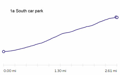
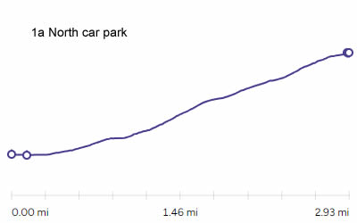
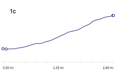
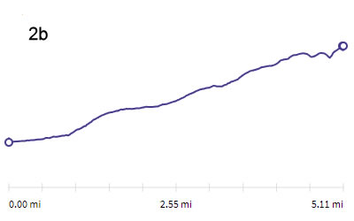
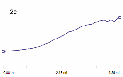
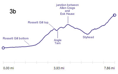
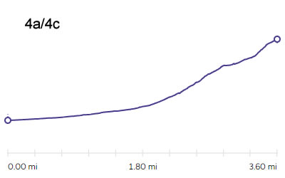
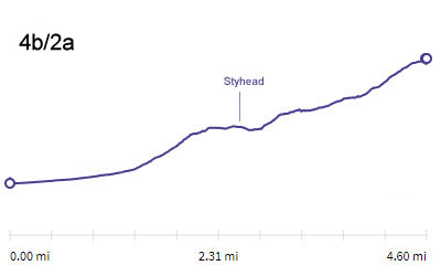
| These show how the land changes as you walk towards Scafell Pike on each route. They only give general information as to how the walk changes as you go along, for example you can see that 1b is steeper early on as you climb Lingmell, but then become easier. Routes 3 and 4a have a very gentle walk in to start with before getting steeper later on. 3b has a big drop in the middle. Most of the climb in route 5 is in the very last part. Note you cannot compare the diagrams directly with each other, to see which is the steepest. This is because they do not all have the same scale along the bottom. Nor do the lines give the exact angle of the steepness for any part of the walk because the horizontal scale is a few miles but the vertical scale is less than 1 mile. (see the bottom plot for my attempt to solve this.) | |||
 |
 |
 |
 |
 |
 |
 |
 |
 |
 |
 |
 |
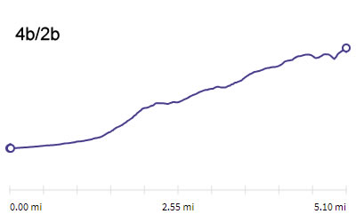 |
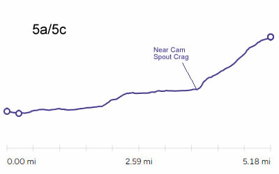 |
||
In this combination plot of the routes they now have the same scales vertically and horizontally and the same as each other. The steepness and length of the routes CAN now be compared directly. I wasn't sure how useful this was really going to be before I created it but I think it does show something that helps to compare the routes. NB some routes have had to be left off this plot for the sake of clarity - 2c, 3b, 4b2b |
 |
||
|
The first four links are to 4 walks by MASARNEN RAMBLERS and are photographs taken throughout each route that they have done. They tend to cover the routes quite thoroughly and will give you a good idea of what some of the routes look like on the ground. |
||
| 15th September 2014 | These photos show 2a on the way up and then 2c on the way back. Rather cloudy weather though. |
|
| 22nd September 2016 | A rather meandering route. 2a up to Styhead then a cut across to 4a. Then a few other wanders to visit minor summits before rejoining the main route and heading up to Lingmell Col and Lingmell summit, then Scafell Pike. 2c on the way back down but ascending Broad Crag and Ill Crag on the way. Nicer weather. |
|
| 9th May 2023 | A lengthy route that also climbs Scafell. Starts on 1a/1c but diverts for Scafell below Mickledore. Drops off Scafell on the other side then joins the top of 5c below Foxes Tarn. 4a for the return. |
|
| 12th May 2023 | 4a/4c up. 1a with a visit to Lingmell on the way down. |
|
| Wasdale MRT advice page | Lots of further information and questions answered. | |
| Mountain Weather | Check the weather up to 3 days ahead. Read carefully. Scafell Pike is in the south west of the lake district so pay attention if any comments mention that area. It is also in the highest area so everything can be more extreme eg often colder than other areas, often in cloud when other areas are clear, often has high wind speed when lower areas are moderate, often has lying snow when other areas have cleared. | |
|
Here are some links to You Tube videos made by other people. I've tried to select a range of videos with different types of walks and walkers, weather conditions etc. I'm focussing on content that shows you what the routes and paths are like but there is other useful input too - map reading, compass use, safety etc. |
||
|
In which two newbies Claire & Simon are sent up by her parents.
1a up from the north car park. A standard fair weather walk. |
2:26 From the car park road looking at the path crossing to the beck and up at the path running across the side of Lingmell. 3:17 Starting through the gate and crossing the field 4:08 Crossing a very dry Lingmell Beck. Nice video of fairly inexperienced walkers so some minor errors here. 5:32 Claire points to what she thinks is Scafell Pike - it isn't, its an outcrop called Symond's Knott, on the side of Scafell. The Pike comes into view at 5:38 and she then corrects herself though you can't see the summit yet. 5:48 shows a map discussion which is being done at the point where the path crosses the ridge of Lingmell and they can see down into Lingell Beck and the path down towards the other car park. 6:37 Simon describes an incorrect route on the map, thats route 1c that he indicates - but they actually take route 1a all the way. 7:13-7:36 shows the approach to the Lingmell Gill crossing and the bottom of Brown Tongue. 8:16 near the junction where 1c turns right. You can just see the 1c path in the distance running around the scree at the top (right side of that valley). Hollow stones is the area ahead on the main path. 9:03 Approaching Lingmell Col. 9:19 Last bit of the ascent. You get a good idea of how rocky the top is. 9:35 Shows Styhead Tarn in the distance. 9:47 They spot a lake in the far distance which Simon describes as really high up - ironically that lake is called Low Tarn, just below Red Pike. 10:46 Summit - Thats a very empty summit on such a nice day by the way. Last time I climbed on that platform I was sharing it with ten other people. There's no coverage of the descent just a brief summary of the timings and nothing else useful for us after 14:03 |
|
|
In which Craig ascends in excellent conditions. 1a up and down from North car park. Similar video to Claire and Simon - rather faster paced but less information. |
0:15 Start across the field. 1:00 Lingmell Beck bridge. 2:10 Turned up Lingmell Gill towards Brown Tongue. 2:35 Crossing Ligmell Gill. 3:30 Approaching Hollow Stones. Junction to 1c Mickledore just ahead. 3:43 Start of the zig-zags. 4:14 I think its a bit earlier to describe this as the final push! 4:25 Turning right at Lingmell Col. The highest fell in the distance to the right is Pillar. 4:37 Brief shot back towards Styhead Tarn and Great Gable. 4:47 Scafell and Symond's Knott in the distance. 5:28 Summit. 5:47 starts descent, same route not so much shown. |
|
|
In which Oli France takes it at a jog if walking up isn't hard enough for you. 1a/1c up from the south car park. 1a down. Shows winter detail of the Mickeldore scramble and how different the conditions can be at the top from those at the bottom. Some good advice throughout from a pro.
|
0:46 Leaving from the South car park 1:55 Crossing Lingmell Gill 4:02 Junction for route 1c to the right 6:22 Starting scramble up Mickledore 8:00 Video now shows rocky path between Mickledore and the summit (Audio recorded lower down) 8:25 Walk up to summit 8:56 Descent 1a - not very busy in this weather !
|
|
|
By The Curb in which Helen and James ascend from Seathwaite and James explores the advantages of putting wet weather gear in your pack and keeping it there when it rains.
2a and 4c up. 3a then 2c down. Generally gives a good idea of all parts of the routes.
|
0:00 Start and along to Stockley Bridge 5:15 heading up 2a from Stockley Bridge. 9:06 at Styhead. 10:30 On the corridor route. 11:44-13:49 Tackling the scramble on the corridor route. 14:25 On route 4c 16:07 joining route 3a at the col. 16:14 summit area 17:30 Descent on 3a, not great visibilty for a while along the ridge. 19:40 Descending towards Esk Hause down the side of Great End. 20:34 Descending from Esk Hause 22:01 Descending Ruddy Gill and Grains Gill. 25:34 Back at Stockley Bridge |
|
|
In which Andrew ascends from Langdale on a lovely day. 3a up.
|
This video takes a different path to my route for the first bit. It leaves from behind ODG and take a route along the Cumbrian way on the east of the valley, instead of across to Stool End, but once in Mickleden its the same main route. Their route is fine and slightly shorter but we wanted to see the lambs in the fields the day we did it. 0:00-2:11 Along Mickleden 2:11-6:28 Climbing Rossett Gill 6:29-7:20 Diversion to climb Rosset Pike (optional - adds half an hour) 7:20-7:44 Ascent to Esk Hause 7:44-8:16 Ascent up the side of Great End 8:16-8:36 Along the ridge 8:37-8:50 Descent of Broad Crag including looking down route 4c. 8:51 Final ascent and views.
|
|
|
In which Andrew and 'Rockstar' Billy go up the side of Piers Gill and do Lingmell as well.
Route 4a/4c up and 1b down
|
Starting in Wasdale Head Andrew walks past the pub and then goes through a gate and across a field to reach the church. There is also a direct road from the car park to the church which my route uses. This is only a minor diversion by him and from the church the routes are the same. This video gives a very good idea of route 4a and 1b down as well. 3:44 Bridge over Gable Beck 4:49 Crossing Lingmell Beck 6:48 Crossing Greta Gill 7:08 Looking up into the bottom of Piers Gill. Climbing alongside Piers Gill. 11:15 The scramble section. 13:55 - 15:25 Diversion to Middleboot Knotts (optional) 15:49 Joining the corridor route and the head of Piers Gill. 16:49 Starting up 4c then climbing the scree 18:47 Final ascent, starts by looking back at Broad Crag and the col. 19:36 Summit 21:00 -21:40 Speeded up descent to Lingmell Col 22:34 Lingmell summit & Crag 25:15 Descent down route 1b 29:42 Joins common path back to North car park |
|
|
In which the Ramble Family ascend from Eskdale on a cloudy day. 5a/5d up in wet weather. 5c/5a down but most of 5c not seen. This video gives a good idea of what the lower part of route 5 is like. |
3:17 Route plan (they end up taking the same route both ways for the lower part but do the two different routes for the upper part) 6:50 Walk Start 8:00 Lingcove Bridge 9:50 In front of Scar Lathing (the crags) and then they take the squelchy path through Great Moss. 11:05 Food with Cam Spout Crag in the background. You can also see how low the cloud is. I reckon its at about 500 metres above sea level so that means a 500 metre climb into it to reach the summit. 11:30 They get a bit lost here. I think they may have accidentally started up the Pen path instead of going further along to Little Narrowcove. 11:36 Walking up Little Narrowcove. I think she is walking up the beck here but Wainwright describes a thin grassy path that runs up nearby and is easier (to the left I think).The weather deteriorates and the video leaps forward in much bigger steps from here. 12:03 summit - a good sequence that shows how easy it is to take the wrong path off the summit in poor visibility and how to find the correct route. 13:05 Mickledore stretcherbox 14:25 Back near Cam Spout Crag. No video of the descent from Mickledore. You get idea of how wet this route can be underfoot in the next few minutes.
|
|
 |
||||
The wide photos on this page have been constructed from even wider panoramic pictures, which is what I mostly do on my website.
The title picture at the very top changes randomly each time the page is reloaded, so I can't make a direct link. Instead, here are links to all the original pictures used in that space. |
|||||||||
Looking east from the summit |
Looking west and north from the summit | ||||||||
| Looking south towards Scafell from the summit | |||||||||
Looking west from Mickledore |
Looking east from Mickledore | ||||||||
Scafell range from Crinkle Crags |
Scafell Range from Esk Pike | ||||||||
Scafell Range from Great Gable |
Scafell Range from Lingmell | ||||||||
Scafell Range from Bowfell |
Scafell Range from Grey Friar | ||||||||
Cloudy Scafell range from Middle Fell |
Scafell range from Middle Fell on a clearer day | ||||||||